
Explore Cornwall on a Paddleboard: The Best Spots You Can’t Miss
If you’re like me and love gliding over water with a paddle in hand, then Cornwall is your go-to destination. This place is a treasure trove of SUP spots, each with its own unique charm. Let me walk you through some of my favourites spots.
Cornwall’s coastline stretches over 400 miles, interspersed with golden sandy beaches, dramatic cliffs, and tranquil estuaries. Inland, the scenery transforms into calm rivers and wooded creeks. The county’s unique geography makes it ideal for various paddleboarding activities.
1. St Ives Bay (Porthminster to Carbis Bay)
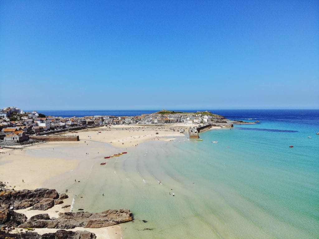
Coastal & Environmental Features: St Ives Bay lies on the north coast but is relatively sheltered by headlands, often revealing calm, turquoise waters even when other north coast spots are rough. Paddlers can launch from St Ives town beaches (e.g. Porthminster) and cruise east toward Carbis Bay. Expect golden sand beaches backed by lush slopes, and occasional sightings of seabirds and perhaps even dolphins further out in the bay. Cliffs separate Porthminster and Carbis Bay. Rounding the low headland (Carrack Gladden) at suitable tide allows you to paddle between these beaches with views of St Ives town behind.
Lifeguard Coverage: Porthminster Beach has seasonal RNLI lifeguards daily from mid-May to late September (10am-6pm). Carbis Bay is lifeguarded only in the peak summer (mid-July to early September, 10am-6pm). Both beaches are generally safe in calm conditions, but always avoid swimming/paddling alone and carry a means of calling for help.
Parking: Porthminster Beach is adjacent to the St Ives railway station car park (paid parking), only a short carry from car to water. At Carbis Bay, a small parking area is available by the beach (at Porthrepta Road), but it is limited and often full by mid-morning in summer. Additional parking can be found uphill by Carbis Bay station or along residential roads, with a 5–10 minute walk down to the beach. Expect to pay a daily fee (£5–£6 in council lots for 24 hours).
Tides & Wind Conditions: This section of St Ives Bay is usable at most tide states, but mid to high tide makes for easier launching and landing (less distance to carry your board). On spring low tides, especially at Carbis Bay, the water retreats exposing broad sands, so you may have a longer walk. The area is somewhat protected from Atlantic swell by St Ives Head and the eastern curve of the bay, but big north/northwest swells can still generate surf. It’s best to paddle here on calm days with minimal swell. Avoid strong northerly or westerly winds that funnel into the bay and create chop, and be cautious with brisk offshore winds (easterlies) – while they flatten the surface, they can potentially push an unsuspecting paddler out to sea. In short, aim for calm mornings or evenings and check that the surf forecast is low; St Ives Bay can be a north coast haven when other exposed beaches are too rough.
2. The Helford River
Coastal & Environmental Features: The Helford River is a sheltered estuary in southwest Cornwall known for its tranquil creeks and lush wooded shores. Launching from Helford Passage (north side of the river) puts you in an Area of Outstanding Natural Beauty. The water here is usually calm and flat, ideal for relaxed paddling amidst nature. You can explore numerous creeks – such as Polwheveral or the famous Frenchman’s Creek – which are lined with oak forests and rich in birdlife (herons, egrets, and other waders are common). Expect to paddle among moored yachts and alongside upscale riverside homes that line parts of the shore. The scenery includes hidden coves and small beaches perfect for a picnic stop. Marine life is subtle but present: look for grey mullet in the shallows and even the occasional seal near the river mouth. This estuary provides a peaceful, intimate paddling experience away from surf and swell.
Lifeguard Coverage: There are no lifeguards on the Helford River. This is a tidal river environment used by boaters and swimmers at their own risk.
Parking: At Helford Passage (the hamlet on the north bank opposite Helford village), parking is limited. There is a small private car park near the Ferry Boat Inn pub – in summer, a £2 launch fee (as of 2022) was charged for using the slipway/beach here. Spaces can be tight, so another option is to park up the hill along the road (with care not to block traffic) or use the National Trust car park at Durgan (west of Helford Passage). Durgan has a tiny car park and requires a short walk down to the water, but launching from the pebbly beach there is free.
Tides & Wind Conditions: The Helford is tidal and experiences significant water level changes. Mid-tide to high tide is recommended for paddleboarding so that the creeks are filled and navigable (at low tide many creeks turn to mudflats). Be cautious around the turn of the tide – the tidal streams can become surprisingly strong in narrow parts of the river and at the mouth. Fast-moving water on a turning tide can catch you off guard, so plan to paddle with the tide when possible (e.g. ride the incoming tide up-river and the outgoing tide back down). In general, current is not too challenging if you stay in the main estuary around high water. Southerly or southwesterly winds (coming from the sea up the river) can create a headwind as you paddle back towards Helford Passage, and might whip up a slight chop in the wider sections. Always check the forecast – if winds above ~15 knots are forecast, consider choosing a more protected creek or postponing.
Local Amenities: Despite its secluded feel, the Helford Passage area has a few welcome amenities. At Helford Passage there is the Ferry Boat Inn, a pub right by the slipway, perfect for post-paddle food or drink. On the opposite bank, Helford village has the Shipwrights Arms pub and a tea room.
Book onto some nearby paddleboard coaching with Matt who is an excellent guide and teacher.
3. Perranporth Beach
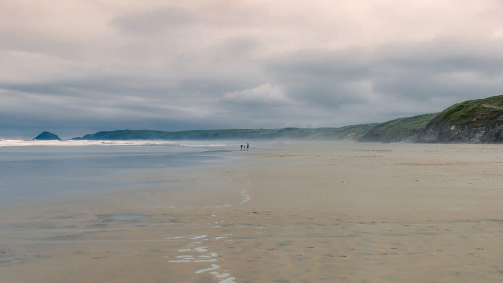
Coastal & Environmental Features: Perranporth is a vast, open beach on Cornwall’s north Atlantic coast, famed for its surf. It offers a dramatically different paddleboarding environment – exposed ocean conditions with rolling waves and long sandy shores. At low tide, Perranporth and neighboring Perran Sands form an enormous stretch of golden sand over 2 miles long., dotted with rock formations (such as Chapel Rock near the village, with its tidal pool). Towering cliffs border the beach to the north (Cligga Head area), and extensive dunes (Penhale Sands) back the northern part of the beach. Marine life is sparse in the surf (aside from fish and crabs in the rock pools), but occasionally dolphins or seals pass by offshore. This location is generally recommended only in very calm conditions for SUP – remember that Perranporth is a big surf beach and gets significant waves. On the rare glassy days or early mornings with no swell, paddling here is magical, with clear blue water and an endless horizon.
Lifeguard Coverage: Perranporth has one of the longest lifeguard seasons in Cornwall. RNLI lifeguards patrol daily from early April through the beginning of November, 10am-6pm – rnli.org.
Parking: Perranporth offers plentiful parking close to the beach. A large pay-and-display car park sits right at the beachfront, next to the surf club and promenade. This car park provides direct access to the sand (a short carry of your board). In peak summer it fills quickly by late morning. Additional parking can be found along the seafront road and at a second council car park a few minutes’ walk away. Charges in summer typically range around £4-8 for all-day parking (card or coin). Off-season, some seafront parking may be free or cheaper. If the main lot is full, another option is Beachfield (Budnic) Car Park on the south side of the beach, or private field parking just outside town in summer. Overall, you should be able to park within a 5-minute walk of the waves.
Tides & Wind Conditions: For paddleboarding, best conditions at Perranporth are when there is no swell and minimal wind. This often corresponds to periods of high pressure or mornings before the sea breeze picks up. If any swell is running, you will encounter surf – small clean waves (under 1–2 ft) can be fun for SUP surfing, but anything larger can be difficult to get through on a paddleboard. There is no truly “protected” tide state here – however, some paddlers find that around high tide the surf zone is narrower (waves break close to shore) which can make for a shorter struggle before reaching calmer water outside the breakers. On the other hand, low tide exposes a very long shallows where waves can reform repeatedly. If you’re set on a distance paddle at Perranporth, target a high tide or early incoming tide on a day with near-flat surf forecasts. Currents: watch out for rip currents, especially on a dropping tide when water is draining off the sands – these typically form near the cliffs or by breaks in the sandbars. While experienced SUPers might use rips to help get out beyond waves, they can carry you north toward the cliffs if you fall off, so stay aware of your position. Wind: Ideal is no wind. A light easterly (offshore) wind will groom any small waves and keep surface conditions smooth, but anything over ~10 knots offshore could make it hard to paddle back in (and increase the risk of being blown out to sea). Common westerly or southwesterly winds (onshore) will bump up the surf and make for choppy, slower paddling but will at least push you landward if you have an issue. Avoid strong winds of any direction here – the combination of strong wind and waves is dangerous for SUP.
Local Amenities: Perranporth is a lively beach town, so you’ll find everything you need close at hand. Adjacent to the beach is The Watering Hole, a bar/café actually on the sand (famous as Cornwall’s only bar on a beach) – a great spot for refreshments while watching the waves. There are public toilets and beach showers by the main car park. Numerous cafes, takeaways, and pubs are within a 2-minute walk in town, as well as grocery shops for supplies.
4. Fowey Estuary
Coastal & Environmental Features: The Fowey Estuary is a flooded river valley on the south coast, offering a mix of scenic river paddling and coastal exploration. The estuary is part of an Area of Outstanding Natural Beauty, with wooded hills and quaint villages lining its banks. Launching from Fowey’s Town Quay or nearby Caffa Mill slipway, you are immediately in a picturesque harbour surrounded by pastel-colored houses and bobbing sailboats. Paddling towards Polruan (the village on the opposite bank) takes you across the deepwater channel where ferries and yachts may be active so keep an eye out for boat traffic. The water here is usually calm, as it’s well sheltered from open-ocean swell by the natural harbour mouth.
As you head out towards the mouth of the estuary, you’ll enjoy fantastic views: Polruan’s old blockhouse fortifications on one side and Fowey’s St Catherine’s Castle on the other guarding the entrance. Beyond that, the coastline opens up – there are small coves and sea caves near the mouth that are fun to explore on a flat day. This area has a rich smuggling history, and discovering hidden caves from your paddleboard can feel like stepping back in time. Upriver, the Fowey extends many miles inland. If you paddle north (upriver) from Fowey town, you’ll pass wooded banks, creeks, and the quiet village of Golant, eventually reaching Lostwithiel at the tidal limit. Wildlife includes swans and wading birds, and you might even spot an otter in the upper estuary.
Lifeguard Coverage: There are no lifeguards on the Fowey estuary or harbour. The waters here are used by boats, so any rescue services would come via the Coastguard or the local RNLI lifeboat station (Fowey has an RNLI lifeboat nearby, but it’s for emergencies, not supervision).
Parking: Fowey is an old town with narrow streets, so parking near the water requires some planning. The Town Quay itself has very limited short-term parking (basically for loading only). The best bet for paddlers is the Caffa Mill car park at the end of North Street, near the Bodinnick car ferry slip. Caffa Mill is a long-stay car park right by the water, and it has a public slipway adjacent – perfect for launching SUPs. From your car to the water is only a few meters. Parking fees are around £5-£7/day in season. Another option is the Main Car Park up the hill above Fowey (near Hanson Drive), it’s larger, but you’d have to carry your board down through town (about 10 minutes walk, mostly downhill). If you’re considering launching from the Polruan side, note that Polruan has an even smaller car park on the quay (often full) and one at the top of the hill, meaning a steep walk down with gear. Many choose to park in Fowey and take the foot ferry across to Polruan if they want to paddle that side. However, given Caffa Mill’s convenience and the availability of hire there, it’s usually the preferred launch point.
Tip: If paddling upstream (toward Golant), you could park at Golant Village (there’s a small car park by the pub) or even at Lostwithiel’s Coulson Park, which is mentioned as a launch spot with direct water access, but those are farther from the “town quay to Polruan” area that this section focuses on.
Tides & Wind Conditions: The Fowey estuary is tidal up to Lostwithiel. Around Fowey town and Polruan, the tidal range means that at low tide, some foreshore rocks are exposed (especially in coves like Readymoney), but the main channel always has plenty of depth. Mid-tide rising is an excellent time to start a trip here – the incoming tide will give you a boost if heading upstream, and if you turn around near high water, you can ride the ebb back down. If you plan to go out toward the harbour mouth or coastal coves, try to do that around high tide slack when currents in the mouth are minimal and there’s enough water to get into little bays. The estuary’s currents are not extreme, but on a strong ebb (falling tide) the flow seaward can be a few knots in the narrow sections.
Wind-wise, the valley shape means winds tend to blow along the estuary’s length. A southwesterly wind (prevailing in Cornwall) will blow from the sea into the estuary – this can create choppy conditions at the exposed mouth and a headwind as you paddle back inland. A northeasterly wind (offshore from the sea) will be behind you going out but against you coming back; it can flatten the sea outside, but you may struggle against it on return, so plan accordingly. In general, winds under 10-12 knots are preferable for comfort. If it’s calm, you can easily explore both upriver and the outer harbour in one outing. Finally, if venturing beyond the estuary mouth towards open water (e.g., around Gribbin Head or Lantic Bay), only do so in very settled weather and slack tide, as the sea state can change quickly once outside the protection of the headlands.
Local Amenities: Fowey and Polruan provide plenty of amenities for paddlers. In Fowey, right by the Town Quay and along Fore Street there are cafés, pubs, and shops. You can grab a takeaway Cornish pasty or coffee before setting off, or enjoy a meal after paddling at a waterside pub (like The Ship Inn or King of Prussia). There are public toilets at Town Quay and Caffa Mill (useful for changing into wetsuits).
5. Padstow Harbour
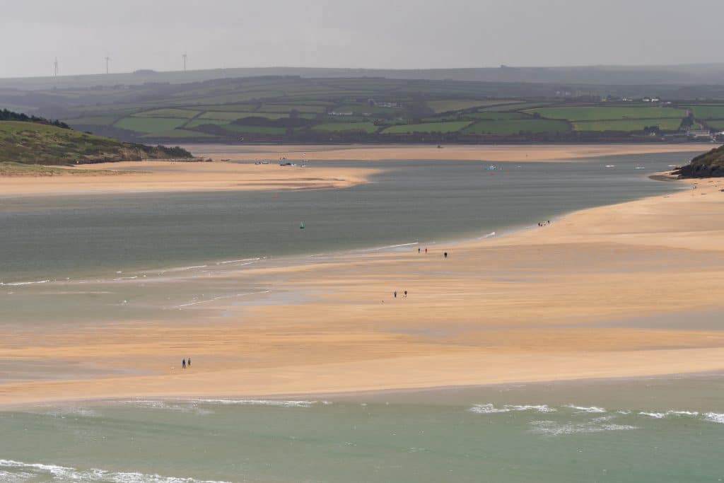
Coastal & Environmental Features: The Camel Estuary, stretching from Padstow Harbour inland to Wadebridge and out towards the Atlantic, is a beautiful and diverse paddleboarding location. It is a broad, sandy estuary named after the River Camel, which flows into it. At high tide, the estuary becomes a wide expanse of blue-green water, with relatively gentle currents and no breaking waves, essentially a huge saltwater lagoon that’s perfect for SUP. At low tide, vast sandbanks emerge.
This area is rich in wildlife: the estuary is known for its birdlife, including waders and migratory birds (it’s a designated Camel Estuary bird sanctuary). Paddleboarders may also encounter curious seals, and there have even been sightings of dolphins or porpoises at times in the estuary waters. Starting in Padstow Harbour, you’ll be amidst moored fishing boats and the bustle of this popular town, but as you paddle out, the scenery opens up to dunes and sand on the west (Daymer Bay side) and gentle hills on the east (Padstow/Rock side). A classic SUP journey here is to paddle from Padstow to Rock (or vice versa) across the estuary. It’s only about a 1-mile crossing and provides a lovely view of both communities. Another popular route is up the estuary: you can paddle with the tide inland under the old railway bridge (part of the Camel Trail) towards Wadebridge. Upstream, the environment becomes quieter and more rural, with salt marshes and cattle grazing on the shore. Downstream you can paddle out to Hawker’s Cove and St George’s Cove, or even towards the estuary mouth near Stepper Point.
Lifeguard Coverage: There are no lifeguard patrols on the Camel Estuary itself. The surrounding open-coast beaches (such as Hawker’s Cove, or further out, Polzeath on the west side) do have seasonal lifeguards, but any paddleboarding within the estuary (Padstow Harbour to Wadebridge, and around Rock) is outside of lifeguarded zones.
Parking: Padstow has multiple car parks. The nearest for launching is the Harbour car park (Locally known as the “Town car park”) right on the waterfront by the harbour. It offers immediate access to the harbour slipway for launching. Alternatively, the Railway Car Park (by the Camel Trail) is large and a 5-minute walk from the harbour; this may be a better bet on busy days. Rock (across the estuary) also has a car park near the ferry and Rock Beach. Wadebridge (upstream) has parking by the Camel Trail where you could launch at the old wharf by the bridge. For most paddlers, Padstow or Rock will be the starting point. Expect daily parking fees of ~£5.
Tides & Wind Conditions: The Camel Estuary is very tidal, at low tide it largely empties, leaving just the river channel winding through mud and sand. Therefore, planning around the tide is crucial. For the best experience, aim for mid-tide rising through high tide. On a rising tide, previously dry sandbanks submerge, allowing you to explore more areas (like the channels behind Doom Bar or around islands of sand). High tide gives the deepest, widest coverage, the estuary becomes a serene paddling spot, especially at high water when it’s fully navigable. As the tide then falls, you can use the ebb current to help carry you back if you’re returning downstream. The tidal currents in the Camel Estuary can be moderate (a few knots in the main channel at peak flow), so novice paddlers should avoid going against a strong tide. As an experienced paddler, you can use the tidal flow to your advantage – for example, paddle up to Wadebridge on the flood tide, then back to Padstow on the ebb.
If you venture near the mouth (Hawker’s Cove), do so around slack high tide when the currents are weakest and there’s minimal wave action. The infamous Doom Bar (a sandbar at the estuary mouth) can have breaking waves on an outgoing tide or with onshore wind – avoid that area unless you know what you’re doing. In fact, it’s best to stay well inside the estuary unless conditions outside are exceptionally calm.
Wind: The estuary is somewhat sheltered from open ocean wind, but it is still an open area that can get choppy if winds are strong. The orientation is southwest-northeast. Ideally, aim for winds under 15 knots. In lighter winds, any direction is manageable – you’ll just adjust your route (for instance, hugging whichever shore offers lee shelter). Many paddlers enjoy the Camel early in the morning, when winds are calm and boat traffic is minimal. One more tide tip: at lower tides, you can actually take breaks on the exposed sandbars.
Local Amenities: Both sides of the Camel Estuary are well-served. Padstow is a tourist hub – right off the water you’ll find countless cafés, pubs, and the famous pasty and ice cream shops. There are public toilets by the harbour and at the car parks. Rock has a few cafes (the Blue Tomato Cafe overlooking the water is popular) and the famous Mariners pub up the hill. Overall, the Camel Estuary is very paddler-friendly and a highlight of Cornwall’s north coast.
6. River Fal
Coastal & Environmental Features: The River Fal, especially at Malpas near Truro, provides a serene inland paddling experience with tidal waters winding through green Cornish countryside. Malpas is a small riverside village just downstream of Truro, where the Tresillian River and Truro River join to form the Fal. Launching here, you’ll be on a broad river that soon opens into the upper reaches of the Carrick Roads (Fal Estuary). The surroundings are idyllic with wooded banks, gentle hills, and very little development apart from a few houses and pubs. Upstream (toward Truro), the channels get narrower, and at high tide you can paddle right into Truro city harbour (passing under a couple of low bridges if tide allows). Downstream from Malpas, you enter a larger expanse of water with multiple creeks and inlets to explore: Turnaware Bar, Roundwood Quay, and further down, the beautiful Ruan Creek and Lamorran Woods on the west bank.
The Fal is a drowned river valley (ria), so even far inland it feels like an estuary with tidal influence but no ocean swell. Wildlife is plentiful: look for herons, kingfishers, and even peregrine falcons in the woods; the mudflats at low tide attract wading birds. Uniquely, the Fal has several historic shipwrecks and ship moorings. In certain spots (like in the channel off Roundwood Quay) you may paddle over submerged wrecks visible at low water, and at times large ships have been laid up (anchored) in the estuary when not in use. This can be an impressive sight, paddling next to a big ship in the quiet river. The character of the paddle can vary with tide: at high tide you float atop glassy waters through submerged wooded valleys; at low tide you navigate the river’s bends with mudbanks flanking you and perhaps need to stick to the deeper channels. It’s an atmospheric, calm water paddle, perfect for those who enjoy nature and long exploratory trips.
Parking: Malpas has limited parking. The usual launch spot is near the Heron Inn pub where there is a small public parking area (a few spaces) and additional patron parking for the pub. On a quiet day you might park right by the slipway (which is just a concrete slip in front of the houses) giving immediate access to the water. If those few bays are taken, you can park along the lane approaching Malpas (just ensure you’re not blocking driveways or the road). Parking is free in this area.
Another alternative is to launch from Boscawen Park in Truro (about 1 mile upriver): there is a large free car park at Boscawen Park and an easy slipway into the Truro River, but only usable around high tide. From there you can paddle down to Malpas and beyond. The advantage of Boscawen Park is ample parking and fresh-water taps (it’s a public park with facilities). The disadvantage is you need a sufficiently high tide to avoid mud.
If you’re set on launching at Malpas proper, try to arrive early to snag a spot. After your paddle, the Heron Inn is right there, many paddlers grab a meal and ask the staff if they can leave the car a bit longer, which is usually fine if you’ve given them business. Lastly, note that Malpas is at the end of a no-through road from Truro; it’s a quiet village, so be respectful of residents when unloading gear.
Tides & Wind Conditions: The River Fal at Malpas is tidal and timing is everything. High tide is the best time to set off, especially if you plan to explore creeks and venture into Truro or upriver sections. At high water, you can paddle over submerged mudflats and reach otherwise inaccessible spots. Low tide in the upper Fal will leave large mud banks exposed. It’s often recommended to only paddle from Malpas from about 2-3 hours either side of high tide (particularly if going into Truro or the side creeks)paddling.com.
If you paddle out from Malpas on a falling tide, remember that when you turn back, you’ll be going against the flow. Many paddlers plan a trip to coincide with riding the tide: e.g. launch at high, go out exploring as the tide turns, then come back with the flooding tide (or vice versa). If heading down towards the main Carrick Roads (Falmouth Harbour), be aware that past a certain point (around Roundwood or King Harry Ferry area) the estuary widens and currents slacken, but wind exposure increases.
Wind: Malpas is quite sheltered from most winds by the surrounding hills and trees. Even if it’s blowing a gale at sea, it might just be a breeze up the Fal. However, strong winds from certain directions can channel along the river. Generally, conditions here are best with winds below 15-20 knots; above that, in such a narrow river, you’ll struggle on whichever leg is against the wind. Lastly, watch out for the King Harry chain ferry if you venture that far down (around 3 miles downstream of Malpas). Give it a wide berth and cross behind it, as it has cables under the water.
Local Amenities: Starting at Malpas, you have the Heron Inn right at the launch, a highly regarded pub with great food and river views. Truro, being the county’s capital, has everything: supermarkets, outdoor shops (for any gear needs), cafes, etc.
One highlight is Trelissick Gardens (National Trust), they have a landing beach and a café up in the gardens; if you land there (on the west bank, near King Harry Ferry) at high tide, you could walk up for cream tea. Another potential stop is the Pandora Inn in Restronguet Creek (though that’s a bit far from Malpas for a casual paddle – about 4-5 miles one way). If you planned a big day, you could paddle from Malpas down to the Pandora, which even has a pontoon for customers’ dinghies, paddleboards welcome too.
If you are looking for places to stay, Cornwall has some of the best campsites in the country.
7. Gyllyngvase Beach, Falmouth
- What’s Great: This spot is a family hit. The waters are calm, and you get a beautiful view of Pendennis Castle. There’s plenty of space to launch your board, and the beach vibe is just perfect.
- Ideal Visit: Go in the summer. The water’s warm, and the beach has a fun, lively atmosphere.
8. Hayle Harbour: A Hidden Gem for Paddleboarders
- What Makes It Special: Hayle Harbour, with its unique blend of industrial heritage and natural beauty, offers a tranquil paddling experience. The sheltered waters of the estuary are perfect for spotting wildlife, and the views of the dunes are spectacular.
- Ideal Visit: Summer and early autumn are perfect, with calmer waters and fewer winds. The estuary becomes a serene paddling spot, especially during high tide when the water is deeper and more navigable.
- Paddling Route: Start at the town quay and head towards Copperhouse Pool. You’ll pass by an array of birdlife and might even spot seals. The contrast of the old industrial buildings and the natural surroundings makes for a unique experience.
- Why It’s a Favorite: Hayle Harbour is less crowded than more popular Cornish spots, offering a peaceful paddle. It’s a place where history and nature intertwine, providing a unique backdrop to your SUP adventure.

9. The Lizard Peninsula: SUP in Cornwall’s Most Southerly Point
- Why You’ll Love It: The Lizard Peninsula is a mix of rugged cliffs, secluded coves, and picturesque fishing villages. The waters are crystal clear.
- Best Time to Paddle: Late spring through to early autumn is ideal. The weather is milder, and the sea conditions are generally more stable, making it perfect for a range of paddling experiences.
- Suggested Route: Start at Kynance Cove, famous for its turquoise waters and serpentine rock formations. Paddle along the coast towards Mullion Cove or, for the more experienced, head around the Lizard Point itself. Be sure to check the tides and weather, as conditions can change quickly.
- What Makes It Stand Out: The Lizard Peninsula is a place of natural beauty and diverse wildlife. It’s not uncommon to see seals, dolphins, and a wide variety of seabirds.
So, there you have it! Cornwall isn’t just about the beaches – it’s a paddleboarder’s paradise. Each of these spots has its own story to tell. Grab your board and see you on the water!